NOAA is not quite as bullish on cold weather for the mid-Atlantic...
http://www.noaanews.noaa.gov/stories2014/20141016_winteroutlook.html
Cold weather and snow now or next week is nice, but we all know where we are and it is not yet winter in the Mid-Atlantic. I would rather it be 90 degress now and then have cold when it counts, starting on or about Nov 19 so snow making can get started and the lake effect machine can be turned on. Weather patterns seem to last for about a month, so we don't want the west-to-east weather pattern to return in later November or early December....unless we want to go fishing in the Outer Banks.

I had a very memorable 2-day fishing charter trip out of Hatteras back in 2007. Four of us caught well over 400 lbs of fish in very rough seas. And somehow I did not get sea sick. But yes you are correct, the Outer Banks is a very special place...the Almost Heaven of the east coastal area. I hope to return one day and fish again.
Check this out from the Kentucky Weather Center....my favorite local weather site...
Posted on November 4, 2014 by Chris Bailey
Good afternoon, gang. We know about the cold on the way later this week into next week, but what about later in the month into December? I took a peek at the GFS Ensemble analog composite for the upcoming pattern.
Check out the years that match”¦
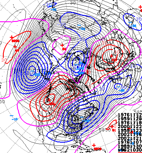 1976/77 shows up three times on the list and that was a legendary winter. 2002/03 is on there twice and was a cold and snowy winter. 1959/60 featured blockbuster snows in February. 1989 gave us the coldest December ever with 2000 not too far behind. 1962/63 was just flat out a brutal winter.
If we put all the years together, here’s how November looked”¦
 And December”¦
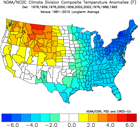 That is a ton of cold showing up should the pattern continue along the same lines as the analog years.
Another update comes your way this evening. Take care.
Fish, actually I will be speeking for John L until his return, as his acting press agent...he has reviewed my qualifications and he has noted my job skills/qualifications...John is doing well and focusing on pow slaying missions for the 2014-2015 season.
fishnski wrote:
...shows the 2 cold shots..with a few inches of snow for the western front areas and into the large dome of cold coming in next week which im hoping gets SS..Wisp..and 7springs up and blasting.....http://weather.bloginky.com/
Looking at some of the very extended forecasts it looks like 7 springs, wisp, and some of the other PA resorts could potentially make snow nightly from mid next week through thanksgiving.... what are the odds that any of these resorts jumps on the opprotunity for an early opening? I have passes at the SnowTime resorts.... but I know I'd me more than willing to take a drive for mid november snow!
Of course forecasts can change... but we can always hope
fishnski wrote:
........yeh.....76/77 was probably the coldest winter I can remember...the whole friggin Chesapeake froze over!...........
This was back when everyone feared the coming ice age and margarine was good for you. How times have changed.
FishNSki,
I am going to the Bengals/Browns game tonight in Cincinnati. Could you give me advice on what the weather will be like? The news says there is 30% chance of rain at game time. However reading your predictions I feel like you may have a better grasp on this than the weather.com folks do.
That's awesome! Thank you sir. I will be sure to bundle up.
Wild weather here in morgantown today. Sunny 1 minute and stormy the next. We had hail about 30 mins ago and now it's gorgeous.
Looks like something's blowing in on the 4:30 CV Webcam.
Snowshoe, blah blah blah... snowshoe....blah blah blah. It has deceptively become the poster child for snow reporting in WV on the news, etc etc because the resort is at the top of the mountain...duh.... If we measured snowfall at the top of the ski areas in canaan we would have identical totals and maybe more.
Glad to see the snow making....something for the folks not afraid of physical/cardio exercise to ski on till the real stuff flies! :)
fishnski wrote:
..29 at 4800' SS...snow top to
...ill be happy just seeing guns blaring!
fishnski wrote:
.29 at 4800' SS...snow top to bottom there....32 at 3715' Canaan and 2.1 inches reported....snow level was about 3500' and up.....no snow further north up at 7Springs per cam........ill be happy just seeing guns blaring!I have many rants on record over the years about ur latest bitch Chaga....thats why I put elevations to my data...im all about Canaan bud....could have picked SS for my winter camp but didnt....not sure why u took my post out of context..............gettiny back to wx....When I started this thread a while back I correctly called this cold air coming as a dome....its huge!...its not a spike down like so many...or even a deep push like the ones that go all the way to fl...but a huge mass that will effect a huge portion of the country.....my brother in the Boulder co area will go from the low 70's to highs in the teens....and the lows...fget about it!......
fishnski wrote:
Cold here from the 12th till further notice...snow skimed fri then. The 17th looks interesting...What I posted a couple of days ago still stands....anybody have Nat Gas stocks?....NWS catching up.........................Snow showers likely, mainly before 4am. Mostly cloudy, with a low around 13. Chance of precipitation is 60%. Friday A chance of snow showers. Partly sunny, with a high near 22. Chance of precipitation is 30%. Friday Night A chance of flurries. Partly cloudy, with a low around 15. Saturday Mostly sunny, with a high near 26. Saturday Night Partly cloudy, with a low around 20. Sunday A chance of snow. Mostly cloudy, with a high near 30. Chance of precipitation is 50%. Sunday Night Snow showers likely. Cloudy, with a low around 18. Chance of precipitation is 60%. Monday A chance of snow showers. Mostly cloudy, with a high near 24. Chance of precipitation is 40%.
Interesting.... from the Kentucky Weather Center web site
There is a new version of the GFS that’s set to take over from the current model. It’s running as a parallel version until it fully takes over later in December. Here’s what it shows”¦

a few days old but.....
"From: Robert Leffler
Date: Sun, Nov 9, 2014 at 8:29 PM
Subject: Upcoming Cold Weather in the Canaan
Your Fearless Canaan Weatherman sees a rather lengthy period of cold, below average temperatures settling into the Canaan and surrounding WV high country. I expect it to begin late this Wednesday and continue out for a week or so at least. Right now, I do NOT see much snowfall accompanying the colder conditions in the WV highlands through Saturday as some private forecasting companies have indicated.
Normally when cold air invades the Canaan, it moves in after crossing the Great Lakes, picking up moisture as it does so, and dumping upslope snows and/or enhanced lake-flake snowfall in November when the Great Lakes are still relatively warm and unfrozen. However at this time, it appears that the invading Canadian air mass will be unusually dry with a trajectory out of the mid-west, (not over the Lakes with little moisture to release. Other than a few snow showers around mid-week as the cold air initially works in, this may result in an unusually cold, dry period for the Canaan into the weekend.
While are some hints that early next week the pattern will become much more active with several significant storms possible, it's way-to-early to get too excited about that possible scenario. Lots can change with the weather 7 days out.
I will update you if anything significant develops. In the mean time I recommend you stay tuned to your local National Weather Service broadcasts for updates on the approaching cold period.
Your Fearless Canaan Weatherman"
http://www.whitegrass.com/nov2014pics/DSC01696.jpg
hope you guys get a big dump.
BUT- I moved to CA in part for the legendary snows of the Sierra. Right now there is nothing happening and nothing in sight. I tell ya', it ain't right! It's bigger than just skiing. CA is in big trouble if normal snows do not return to the Sierra this winter.
70s here at the moment but Snow Miser should be back Friday night.
crgildart wrote:
... Snow miser?....no spick............. ...ive stuck to my guns for...days.. Now for a brush of snow fri and a very interesting event on mon the 17th....NWS has been calling for snow and snow showers mostly on sat into sun.(15th/16th).....there was blogging chatter for the 21st...but its to warm for that one...cold will/should come back for tgiving.......seems to be a lot of confusion in the wx geekisphere and even with our Govt wx agency...Im too stupid to get too crazy with some fcasts...I just watch each model and watch for trends... U watch Joe Bastardi and many others where they bring all these different Wx setups AO. NAO...enso...modiki...pdo...osolate this...push this...pacific temp this...atlantic temp this....ect..ect...ect....drive ya nuts!!!70s here at the moment but Snow Miser should be back Friday night.
Forecast for the Laurel's....good for early snow making.
Tonight

Flurries
Low: 27 °F
Thursday

Chance
Snow
High: 34 °F
Thursday
Night

Chance
Snow
Low: 22 °F
Friday

Chance
Snow
High: 30 °F
Friday
Night

Mostly
Cloudy
Low: 21 °F
Saturday

Mostly
Sunny
High: 34 °F
Saturday
Night
Mostly
Cloudy
Low: 25 °F
Sunday

Chance
Rain/Snow
High: 37 °F
Sunday
Night
Chance
Snow
Low: 28 °F
Chaga has been dropping the ball on this so here is the Fearless ones Fcast...before I read this i was thinking more like 2 to 8 depending on the that tricky temp playout..8 all snow...2 period of rain with it....I was going to wait for the next model run to get a better handle on the situation but I like the fearless version better..so here it is...
General Discussion: There's the chance of a significant snowfall Sunday night into Tuesday night in the Canaan and immediate WV high country above 3,000 feet elevation over and west of the Alleghent Front (eastern Continental Divide). While the risk has increased in the last couple days, many uncertainties still exist at this time, making it too early to make a solid call on amounts. Specifics:Your Fearless Canaan Weatherman expects a moderately moisture-rich disturbance to form in the Gulf of Mexico ahead of yet another strong push of cold Arctic air beginning early Monday morning. The system will move northeast if it develops. The track, speed, and intensity of this developing storm will all combine to determine whether the precipitation is rain-changing-to-snow or all-snow across the high ground west of the Allegheny Front. At this time, temperatures look to be marginal at 3,000 feet elevation and above initially for snowfall as the system rides up to the northeast on a track southeast of Canaan. Small difference in the track and intensification rate can significantly impact snowfall amounts. A track only 25 miles farther inland will mean rain-changing to-snow with lesser amounts while the current more likely track favors a very close call but all snow on the high ground. A track farther to the southeast, while colder, will reduce all precipitation type amounts. The speed of a warm-up between a current then retreating cold air mass and the next approaching push of frigid air also plays a role in the precipitation type initially. While still too early to pin down snowfall amounts, totals of 5-to-10 inches over the 2-day period are not out of the question if the precipitation stays all snow. After the system passes to the northeast of Canaan, brisk NW winds will generate blowing snow and some upslope snows (included in the 2-day snowfall totals) into early Tuesday evening. Much below average temperatures will follow for several days into Thursday with Tuesday afternoon temperatures staying in the teens (with lower wind chills) and morning minimums zero to 9 F so be prepared for this early cold blast! As always, snowfall amounts for my forecasts are verified by the official NWS publsihed COOP weather observer on Canaan Heights. I will provide updates as this mid-winter-like scenario continues to develop. In the mean time, stay tuned to your National Weather Service local weather forecasts for more rapid updates. Your Fearless Canaan Weatherman
PS...like Mr Snowsmith said...enjoy the cold while we have it....looks like the snow making crews are going to have to work hard to find those snow making windows when this cold spell passes...your fearless snowhound..(me) will be sniffin the air for that tingle!...ok...nerdoski has left the house....
Here's one from that WXRisk guy.

fishnski wrote:
Still thinking a white TGiving and hoping the 4 letter word doesn't pop up for Sat......spending winters in the Tampa area now puts me a longggggggg way from the Mtns so as I sit here waiting for Mr Ups to bring my new XC ski pkg I dont see anything to lure me out of my sunny 70's...could be a week or so of a warmup later tgiving into dec...looking for that Snow lure dump before XMas!....fingers crossed for u turkey skiers!
Hey fish, what's he bringing you?
well....thxs for askin Jimmi..me luvs ya long time,,btw....last year I rented a few times..my first on XC ever...I dont even know what i rented and they were alot of work but got easier and funner as i went along..they were all plastic and I started to look for a sturdier ski for more aggresive turning and control..get off the track a little....sooooo...I first looked at the Rosi 65's with the updated version of the rosi 65 touring pkg..they had a partial metal edge and stronger bindings and boots but i ordered that for the ole Lady and went one step up to the fischer 68's with even heaver bindings and boots for way better turning on downhills..fatter in front for bushwacking thru deeper snow but still narrow enough to earn my beers while skating on whitegrasses tracks....there are way more aggresive ski packages out there that cost a whole lot more than mine but I think for my level ill be fine.....cant wait to wake up one morn at my WV camp after a dump.. or while it still dumping even better.. and just pop those billies on and take a tour of the hood before breakfast!
Are you saying it's going to rain? I will be leaving the Balto area late Wednesday afternoon to head up to the mountains and driving in a snow storm with all of those amateur drivers kind of scares me.
For whatever it's worth I've already been skiing in Okemo twice (weekends) and it's been quite acceptable. And it's a week before Thanksgiving! 26 trails with 6 lifts, two top to bottom (2,200' vertical) and about 10 runs from the higher lifts to the top. Returning to Phila for Turkey Day and hopefully not in a snow storm. We may end up with 10 inches or so on Wednesday.
you're totally correct. Our local weather folks have upped the snow fall in the highlands here to 18".... I decided to leave tomorrow Tuesday instead of braving a closed down I-91 and a mess on I-95 into Philly....
I drove north on I-81 in PA today. The electric signs are all warning about winter weather on Wed, starting at the MD/PA state line Local TV weather in Allentown certainly talking about snow.
Lucky for me I'll be north of Albany by Tue night. Heading up to Lake Placid first thing Wed morning. Hopefully before it starts snowing in Albany and points south.
It looks like winter storm warnings have now replaced the watches. The extent of the warnings is more widespread than the initial watch area too going all the way back to Seven Springs. Does anybody have an updated guesstimate on snow totals?
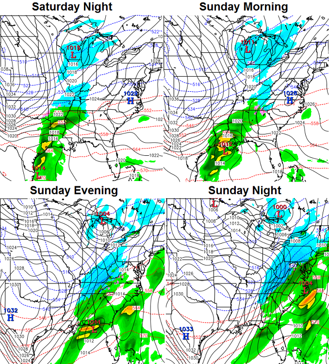
The model runs are suggesting a change next week with a major winter storm going up the coast. This could be the kick in the kiester that the weather pattern needs to change from the miserable, gloomy, damp crap we have now to winter wonderland next week. Thus allowing us ski junkies to get our fix in a higher quality way. And the longer range forcasts are calling for a blocking pattern later in the month, thus providing cold weather approaching the Chrismas holidays.
"Your Fearless Canaan Weatherman believes a significant weather pattern change favoring more wintry conditions in the Canaan is in the works. While rain today may briefly end as some light snow Saturday night, that is not the headline. Bigger changes are in store mid-week.
Colder air arriving from Canada Tuesday will likely generate another coastal storm. As always with a storm not formed yet, the location of development, track, and intensification rate all play a large factor in who gets snow or rain and how much. While way-too-early to discuss snowfall amounts, this system has the potential to throw moisture back inland, creating moderate UPSLOPE snows in conjunction with colder air moving in over the Canaan and surrounding WV high country Tuesday into Thursday.
Right now, I disagree with public forecasts calling for rain-and-snow during this period. If any precipitation falls, I see ALL SNOW. After that system moves to the northeast, it may again warm-up briefly but a more normal pattern supporting the progression of colder air should begin after that.
As always, I will keep you updated as the situation comes more into focus.
Your Fearless Canaan Weatherman"
A set up like this could potentially provide us with some substantial up-slope snow.
I see that the snowfall amounts for our beloved mountains has been increased to 3"- 6". I hope Inaccuweather is correct for a change.
LOL that Timberline has ads here after all of the greatly exaggerated rumors of her demise hahaha..
And, Snow Miser is back in the mountains here. Not getting the precip back there that is headed north but cold enough to blow snow again.
It is dumping on the Snowshoe Cam right now!!
fishnski wrote:
..looking at a quick cold shot the 17th..the 21st..and then the big one the 24th....cross ur skiis!... ...........posted 3 days ago and still holds.....standard pre cold front premature snow to post front snow n cold for the first one...nothing to make plans for...BUT...the 21st shot for next weekend might require a snowhound alert if the EURO model wins the day with thier version of events...GFS brings storm just to the west (not best) side of the high country Alpps which is ur rain to snow scene....XMas still looking like winter kicking in hard...hopefully that stays true..in the meantime...Go Euro for next weekend!
Forecast for today.....miserable, followed by partly miserable, with a dose of mostly miserable.

snowsmith wrote:
Forecast for today.....miserable, followed by partly miserable, with a dose of mostly miserable.
I was in Snowshoe from Thu - Sun. Fri and Sat were awesome. Freezing drizzle Sat night - Sun morn. Packed the truck and drove home in rain / drizzle from SS to Pittsburgh. Hoping to post up a video of Sat in a day or two.
Sat pic of the day.

It was foggy AND windy all weekend at HV. Saturday we had freezing windy fog with ice chunks blowing off trees. Today, we had wind, fog and rain all day...sideways mist. I will say the snow conditions were excellent on Saturday.
I have a hard enough time understanding both yours and wxrisk's forecasts, I don't know if looking at models is going to cut it for me!
eggraid wrote:
I have a hard enough time understanding both yours and wxrisk's forecasts, I don't know if looking at models is going to cut it for me!
+1
I actually like that Justin Berk out of Baltimore, MD. He seems pretty transparent with a desire for some level of accuracy. I wish he covered the WV resorts.
fishnski I'm going to have to agree with the previous two posters. I don't know if you are trying to be extra witty or something, but it really is hard to understand what points you are trying to convey. Perhaps consider a more conventional writing approach to get your point across. Go back and read your last few posts and ask yourself if a reader can follow your choppy syntax and understand what was communicated. I hope my comment doesn't anger you. I know you know a ton of stuff and think you make great forecasts, I just have a hard time following you the way you write.
fishnski wrote:
Ive had it with these so called met ......Hypsters....Wxrisk is a prime example.....dude talks so much. Do Do...he is a copy cat and then makes it look like his info...even Joe Bastardi hypes storms...yeh..he..they..get lucky here n there but all screw up big time!.........all the info is out there folks..free!... Its getting so easy to read the models... Which is all those hypsters do.....just look for 850 temps (5000')......look for the 540 line...north of that snow..south...no......compare runs to see the shift...ck out a site that figures snowfall totals and watch the trends on those.....read the fcast discussions on the NWS sites...these joker bloggers would be out of buisness if they didnt have so many sheep following them......that said...it looks like next weekends energy is trending a little south but will still affect the wv Alpps....ck out the next model run...Nam should be out..gfs will follow...canadien and Euro wont put out any new guidance till about 1..to 3..am.....wake up and ck em out like me!........yeh right....
I've never had a problem understanding "Andyspeak." But then again we do hang out in the same neighborhood in the mountains.
Yeh..Understood Droogie..never been very articulate......but if u can ever dicifer what im trying to mumble u will see a 99% accuracy rate in my droolings...im talkin about going back what..14..15 years?..I consistently beat any fcasts by many days in advance..I find big storms many..many days in advance.....I have watched many folks come on this site over the years putting out fcasts that I know are way off....I try to be responsible and not to hype any storms..to be honest scott never liked any of us to fcast anything without siting scources that were reputable...he warned us a few times but Im hoping he gave up on me after he could see a pattern of truth..or he just gave up..lol...
OH...I have been posting on a smartphone which is hard for me to do...small and hard to edit...I know im a caveman..admitted that many many times...
PS...THE WESTERN AREA HIGHCOUNTRY SKI AREAS (ALPPS) WILL HAVE A WHITE XMAS>>>JUST LIKE I PREDICTED A WHITE THANKSGIVING PROBABLY 9 DAYS BEFORE THE DATE>>>>...there...think ya can understand that?!
ALPPS...allpine in the apps...
Thanks Kwill!!..ill take any kind of support..what is ur fav beer?...see ya in the pub!
Oh...one more thing..when I started this thread and knowing my limitations i asked for as much participation as I could get..thx for the snowsmiths and Dons and a couple more folks for the imput...was hoping for more of uall and way less of me to tell u the truth...anyhoot think snow n cold!
One last thing..sorry...My last rumblings began out of frutrations that the Met bloggers will hang on to any model that will give them the most fodder to hype for their sites..they have all stuck to this huge storm for this weekend and a dude like Wxrisk hates to back down even when it looks like the brunt of the energy has shifted further south of where we need it..he will keep grasping...I hope he is right..more snow the merrier!...but im not feeling the big one...thats what i was trying to say and i cannot put my thoughts down any better than that..fgive me..
I actually like that Justin Berk out of Baltimore, MD. He seems pretty transparent with a desire for some level of accuracy. I wish he covered the WV resorts
I did follow mike masco out of balto for awhile..same prob....found this FB site...https://www.facebook.com/WvEasternPanhandleWeather.........but then again they were hyping this storm till they threw in the towel at 11am this morn..Soo..u can see I that just because i follow them doesnt mean i follow them..follow me?..yeh..that was my attempt at being witty Droogster..
How snowy a X-Mas if I might ask Mr. Fishnski? PS - your weather reports are one of the most useful things on this site. Thanks
TomH wrote:
How snowy a X-Mas if I might ask Mr. Fishnski? PS - your weather reports are one of the most useful things on this site. Thanks
Wow..this thread might cost me some funds at the pub..trying to sneak in some free beer mr H?...thx though......nice folks here on DC Ski..when im all uppity and cocky here folks love to send me hate... now that im on the ropes and playing defense I will start to get some pitty posts..keep em coming!!....
The long range models have been showing a strong blast moving in around the 24th..I first felt brave enough to bring it up about a week ago..its still there so if we dont get a really strong blast coming in XMas eve then please forgive me for being a sucker!...I have to go back and look at it closer..ive been watching next weekends system and havn't really paid attention to the 24th....
looks like a storm will spin up on the edge of the bulging cold heading our way..spin up to the west of the high country bringing in some rain at first but then bringing in one of those fronts that Canaan is known for...u know..white knuckle driving past Mt storm on the way to Davis and into the Valley?!!.....gotta factor in the upslope and lake factor as we get closer to figure out how much we get....Im thinking..and hoping this is the start to a below ave Jan and Feb...
Chime in folks..let us know what ur hearing and seeing out there!
I know it sounds far away, but it is close enough to get close. And this guys analyzes all of the models and indicates which ones are most likely wrong. He then tracks the progress of each model to see how it is converging with the actual weather. He does not give long range forcasts. He looks at trends and then makes a prediction when he has the information. I haven't found a better forcaster. I wish he would move east. The worst is Accuweather. Given that they are in State College, you would think they could do a better job with the Laurel Mountains.
Actually Mr. Fish I will buy you a beer at Timbers if someone that knows both of us points you out.
snowsmith wrote:
I like him too. He used to be in Charleston, WV which was great b/c he put emphasis on Winterplace and Snowshoe (selfish on my part).
That WxRisk guy is strange. I don't get it, he runs a private weather consulting service and treats people like S__T on his Facebook page. You'd think he'd try to be more professional (like Burk or Bailey) which IMO would attract more clients.
I do like this thread and Mr Fish's alerts - even though he did not like my Miller Lite Beer Can Snow Depth Gauge ..... HA !
What really perplexus me and has for a long time is that when u go to wx blog sites u often see in the comments really good posts that sound smarter and with more sound reasoning than the pro met blogger themselves!...Im just an ole burnout from the hood of DC and Know that there has to be some really smart folks here that know their Wx..why am i the only dumbass that posts?..the few of u that do post dont qualify as "Dumbass"..and wish there was more of you..this is a SKI SITE..WX is one of the most important topics that can be discussed.....maybe if i quit opening up wx threads more of you would would feel like opining...maybe u all are so nice that u feel like u dont want to tread on my "show"....man...Im dying for more thoughts and posts...
TomH wrote:
Actually Mr. Fish I will buy you a beer at Timbers if someone that knows both of us points you out.
Might need the help..I have lost a fortune in oil stocks..ouch...who could have fcast this huge oil drop??!.....maybe if i spent more time studying the market and less time WX watching id be Richhhhhhh!!!!.......yeh Blue Don...get some taste BUDS!.....
I read KyWx every nite around 1ish Snowsmith...that friggin smartphone robs me of sleep...1st the latest GFS model run..then KYWX..then the GEM and Euro at 2 and three am...then the stock futures..fcast discussions...snooze a little then the doglicks to get me up at 7...around the clock!!!....need to go skiing...dont have internet at my camp in canaan...
here is what the gfs is saying three days after the initial front on the 24th...(dusted off a 12 year old dell laptop to post this)...judging by all that blue cold air up north it looks like there will be an initial pullback on the 27th which is shortlived then another push down ..this is 10 days out...just an idea at this point...three days of cold winds blowing from the front till the 27th could bring a few inches of snow or a feet of snow..gotta see which way the wind will set up and if the lakes are still below ave temp wise..how are those lake temps...thats ur homework...
timing of the initial blast and the duration of the 1st wave will have to be watched for....
Some model runs take this storm going up the Ohio valley....very bad for for us DCSkiers since that is the warm side of the storm. We need to ask Santa for this storm to move further east. Otherwise, we'll have a wet Christmas. And I cannot picture Bing Crosby singing "I'm dreaming of a wet Christmas, just like the ones...." you get the idea.
Droogie wrote:
fishnski I'm going to have to agree with the previous two posters. I don't know if you are trying to be extra witty or something, but it really is hard to understand what points you are trying to convey. Perhaps consider a more conventional writing approach to get your point across. Go back and read your last few posts and ask yourself if a reader can follow your choppy syntax and understand what was communicated. I hope my comment doesn't anger you. I know you know a ton of stuff and think you make great forecasts, I just have a hard time following you the way you write.
This is one of the best posts on DCSki in quite a while.
I guess I find it easy to understand Andy's posts, but that's probably because he's been my uncle for nearly 10 years now...Speaking of which, what'd you get your favorite nephew for Christmas this year???
Droogie wrote:
fishnski I'm going to have to agree with the previous two posters. I don't know if you are trying to be extra witty or something, but it really is hard to understand what points you are trying to convey. Perhaps consider a more conventional writing approach to get your point across. Go back and read your last few posts and ask yourself if a reader can follow your choppy syntax and understand what was communicated. I hope my comment doesn't anger you. I know you know a ton of stuff and think you make great forecasts, I just have a hard time following you the way you write.
- i understand him perfectly; his West Virginial - beatnik - Kerouac prose is always a delightful romp. lol . lolol. lo lo. la la la.
Christmas Eve / Day From Crap U Weather this morning

Assuming I read this correctly does it mean miserable weather for the entire Xmas?
skicat wrote:
Assuming I read this correctly does it mean miserable weather for the entire Xmas?
Depends on your location. If things play out exactly as that map shows, 7S, HV, BK, Wisp and possibly CV area could see some nice snow. East of all that .... yuck.
Remember - the pic is from Accuweather. They update regularly and that's 6 days away.
Don't get me wrong, fish, I always come here to check out what you have to say anytime I have someone tell me "did you hear there is a big storm coming next weekend?" I appreciate you keeping us up-to-date, especially with the WV ski areas, even if it takes a couple of readings for me to figure it out. The last few posts have been much easier for me to understand :)
Keep it up!
Im all about constructive critics..tough love..all that..its all good Eggraid...Lord knows ive dished it out at DCSKI..better be able to take it too!........I was laughing to myself last nite thinking that if they couldnt understand me they would LOVE CRUSH doing weather posts..any posts for that matter!..then i see my man posts a response here..lol..u go Crush!...
Taking a quick look at todays runs it still follows what I posted yesterday..first wave crashes in noonish.(give or take) on wed/24th..snows and blows for 24/26 hours..like a wave at the beach it retreats..then surges back a couple of days later..some time later on fri...GIVE OR TAKE!...then continues thru XMas weekend..Should start to get 1st ideas of snow amounts tomorrow..but im gone fishing...heading out 12 miles in the gulf of mexico in AM to catch some Grey snapper for fish tacos!!
PS..that was the good part..but we gotta get thru the wet stuff first...thats life in the mid atlantic!......always looking at the future but this 17th cold shot i posted about many moons ago is showing some staying power..if its not snowing lightly right now it should soon...(western front High country)
Nov was colder than normal..the 1st week in Dec was above but we have gone below since...
PS..part 2..............
| Eureka, Nunavut | |
|
-9 °F Light Snow Low Drifting Snow |
|
| Resolute, Nunavut | |
|
-29 °F Fog |
|
Go Fish Go.
I'll buy ya a beer @ Timbers.
Regards.
For Snowshoe or any other area you want:
Intellicast - Snowshoe Weather Report in West Virginia (26209)
I visit a number of weather sites but Intellicast constantly updates their 10 day forecast and is very accurate! They also have great graphics.
Like TLine, rumors of JL's demise were greatly exaggerated. ;)
fishnski wrote:
The Great JL Lives!!!!!!.....Bow down all ye peasants...we r not worthy......
TLine open, JohnL posting again...I feel like my equilibrium has been restored.
TomH wrote:
Like TLine, rumors of JL's demise were greatly exaggerated. ;)
To their dismay.
I'm sure you have heard about some of their "facility" issues (which will effect some of the skiing.) But "speculation" not allowed here. I'm glad they did open. I don't wish ill on the pass holders or the homeowners.
I'll be curious to get your take on the ops so far at CVR since you know W. Maybe at Timbers tomorrow nite.
Mr. Fish, I'll be curious on any updates for Wed. Won't affect me near term since I won't ski next weekend, but it would be nice to repair some of the likely damage from Tues.
I was going to enter a fishnski tribute post written in his own dialect, but it is IMPOSSIBLE to duplicate. One of a kind mind when it comes to keyboarding through the blizzard of cyberspace. But I hope to meet him someday because he has the sea-n-ski migratory H2O lovefest lifestyle down like a champ. Fish, do you have any January vacancies in your chairlift counseling practice for those seeking to detach from reality and slide into the alternate universe of ski bum fantasy land? I do xcountry too.
Im always concerned when I see someone with a good head on thier shoulders....I mean someone...wayyyyyyyyy above my paygrade posting on one of my threads..dont know if im going to be scolded or critizicized for being a derilect but a guy like Jimk who is such an acomplished guy is obviously very modest and easy going so it would be an honor and a pleasure to spend a few trips up the ole mtn with ya sir....im a freebird and dont make reservations..dates or anything that I might not be able to keep but i always ask around when up in canaan and see known Dcskiers to see who else might be up there....
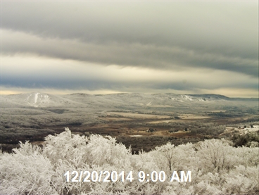
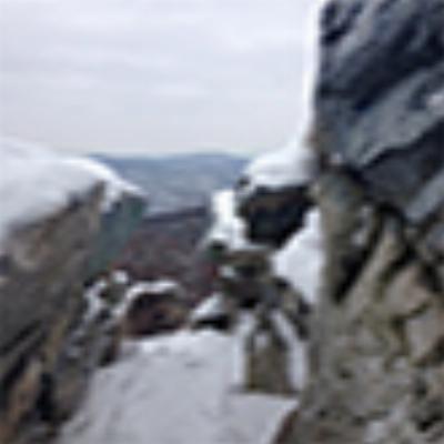
Ck out this morns pic of Canaan on the dolly sods..post card perfect!....see the darker clouds scooting by(mostly shaved south of the alpps)...should have been closer and thicker acording to last weeks fcasts...oh well...still Sweet!......oh... let me figure out how to post it....
fishnski wrote:
Ck out this morns pic of Canaan on the dolly sods..post card perfect!....see the darker clouds scooting by(mostly shaved south of the alpps)...should have been closer and thicker acording to last weeks fcasts...oh well...still Sweet!......oh... let me figure out how to post it....
Beautiful at 09:00 this morning
We enjoyed a light dusting of snow this morning in The Bull City. Not much but the kdis got bundled up and went out early make the most of what they could.
The latest model runs that I have observed seem to indicate that this is primarilly going to be a rain event with a little wrap around snow late Christma Eve into Christmas day. So far we have generally been in a minor 'snow hole' where the snow is not getting to the Appalachians. The weather pattern is supposed to change soon, and hopefully it includes some sustained lake effect stuff. Not the worst weather but a big Xmas snow event would have been nice.
fishnski wrote:
Ok...now that ive come down from my Apres fishing Dum n cokes ill get serious....please correct me if im wrong but I dont see any wx headlines for the rain part...overnight tue and into wed till the front is thru xmas eve will b wet but its not as if its been warm all week...the snowpack is cold..damage minimal.....the snow part doesnt need any headlines either...as far as a snowy place like Canaan relatively speaking......the second shot coming in overnite fri/sat morn is still 8 days out and a little bit of a mystery...hopefully any brief warmup and pre frontal rain will come after fridays skiing.............im deleting all wx blogs from my favs because im tired of being. Swayed by impressive maps..analogs..ect....not looking past 10 days out anymore...8 days out wil start the planning process.....I have a 15 hour ride to wv from fl now and im glad I held off from leaving last week....im looking for snow deep enough for my new xcountry skiis!
I posted that 2 days ago and would have made it a day earlier if it wasnt for a fishing trip I was on....so 5 or 6 days out i pretty much threw in the towel for a big one but still holding out for a white Xmas...there has not been any real model consesus to get a positive read on events...been hard to figure...
Toss in the towel on this one.
Possible (brief) T-Storms in Northern/Central Vermont.
Misery will love company.
Catch some fish in teh next week. After that, hopefully some winter. I got some winter this past weekend, enough to last me a week or so. But no longer.
67 degrees forecasted here in Morgantown on Wednesday.
Bah, Humbug!!!
Rain, rain go away
Please let it snow and snow and snow and snow
The Colonel wrote:
Bah, Humbug!!!
Rain, rain go away
Please let it snow and snow and snow and snow
NWS pittsburg must have listened to ya there Mr. colonel sir.......Last nite they were caling for heavy snow accumulations for the canaan area and this morn they still had this....
- Today Showers, mainly before 4pm. High near 60. South wind 9 to 13 mph. Chance of precipitation is 80%. New precipitation amounts between a tenth and quarter of an inch possible.
- Tonight Rain showers before 2am, then a chance of rain and snow showers. Some thunder is also possible. Low around 31. Breezy, with a west wind 13 to 21 mph, with gusts as high as 48 mph. Chance of precipitation is 80%. Little or no snow accumulation expected.
- Christmas Day A chance of snow showers, mainly before 5pm. Mostly cloudy, with a high near 34. Breezy, with a west wind 20 to 25 mph decreasing to 10 to 15 mph in the afternoon. Winds could gust as high as 46 mph. Chance of precipitation is 40%. New snow accumulation of 4 to 8 inches possible.....
Great white hope?....Nope.....some kind of mess up.....(loser gong show sound..waaaaay..waaa...whaa0..woughhhhhhhh...)
Oh...watching a stalled front for late weekend into next week but think that the Mtn's will be on the warm side of it..but still watching ....looking more promising for new years eve into the new year...looks like what was supposed to happen XMas eve into XMas but of course that changed but odds are swinging in the bullish camp..they have too!!..dang it...
I hate to be the ghost of Christmas past, but the NWS forcast I looked up has the following for Davis, WV:
Not excactly encouraging. I feel like Bob Cratchet after getting my lump of coal from the Weather Scrooge.
David wrote:
67 degrees forecasted here in Morgantown on Wednesday.
over 50 in canaan right now. a little muddy for biking, but great corn skiing conditions....next best thing to powder. #enjoywhatyouhave
U r thinkin with a glass half full mr snowgrinch...ya fgot ta add the overnite snow...U have a choice between little or no snow accumulation.....think positive and chose LITTLE...could be another qtr inch ....livin large up in the snowy Alpps!...
PLUS....im thinking by 1am it will b all snow...gives us another extra couple of hours to add it up...whooo..whooo...
At what point does the winter start looking like a bust? For the next 10 days it doesn't look like there will be any off-piste skiing in WV.
Can someone give me some hope?
Not really hope but some fantasy.
http://www.tropicaltidbits.com/analysis/models/gfsp/2014122912/gfsp_asnow_us_41.png

Droogie wrote:
At what point does the winter start looking like a bust? For the next 10 days it doesn't look like there will be any off-piste skiing in WV.
Can someone give me some hope?
if you listened to all the long range fcasts by all these blogging Mets ( im guilty...wont do it again..as I ranted earlier..)you would have thought that we would be knee deep..for real..in an East coast cold pattern....they love to bring up these wx setups that they think will bring it on but mother Nature is just way too smart for them still!...
Instead what I am seeing is more of a pattern where the storms either are way too south of us or are running up the west side of the Mtn's.
the cold trough actually looks like it is more centered and maybe slightly west of center..(snow in vegas..cold out west..)...in the lower 48..
So we have to settle for the cold back side of the western running storms untill this pattern shifts east....thats the way it looks like Droogie said for the next 10 days..looking further out is just speculation at this point...and you can see what speculation has got us....hey...could be much worse and a ski area like SS can thrive with this pattern...
BOOOOOOOOO!!!!!! Not what I want to hear. :(
fishnski wrote:
hey...could be much worse and a ski area like SS can thrive with this pattern...
So who's gonna blow the most over the next three days?
SCWVA wrote:
So who's gonna blow the most over the next three days?
Damn well better be every resort that has a snow gun. It's hard to justify some of the lift ticket pricing for 1/2 open ski resorts.
Blue Don 1982 wrote:
SCWVA wrote:
So who's gonna blow the most over the next three days?
Damn well better be every resort that has a snow gun. It's hard to justify some of the lift ticket pricing for 1/2 open ski resorts.
Hear..Hear!...there has been a clipper on the maps for the 6th thats been showing pretty consistently...if it pans out they usually put a nice fluff on the western Front...
The Colonel wrote:
Bah, Humbug!!!
Rain, rain go away
Please let it snow and snow and snow and snow
Thanks, your spell worked. We headed up to Appalachian this morning knowing that the forecast was rain likely til 11am then some clearing and mid 40s. What actually happened is the temps dropped and it turned to snow. And it didn't clear up, it snowed all day. The rain earlier this week and last night sent the (other) tourists away and we had no lines for most of the day. It was starting to fill up when we left, but it was still snowing. What a wonderful mistake those prognasticators made hahaha..
I know the 10 day is missing the natural snow...but this is the forecast the snowtime and other PA resorts want to see. I was at Liberty tonight and they were making snow like crazy, this weekend should be very nice and it looks like they are trying to open up some more of the backside very soon. Based on the webcams I would guess whitetail is planing on opening more terrain tomorrow or Thursday as well
After a weekend of a lot of temerature inversions it seems that we will get some snow. Blue knob might get upwards of 5 at the top. As for the snow times whitetail will probably have more. And seven spring probably the most.
Yes!!!!! The weather pattern is flipping! I hope the off-piste/BC can be a go by MLK weekend! Even without major storms tons of snow making terrain will get open the next 10 days.
Looking at Wintergreen MLK Day. Come to Pappa!
Looks like the valley is winning big today. SS, HV and 7S look pretty good too.
I've been wasting the better part of the morning on that webcam site I set up. http://snowcamseast.com/
Winter is finally here!
This is a future thread so I am going to predict a future event....drop down an Arctic high which pumps some bone chillin temps over Canaan reaching an 11 below reading this morn..the arctic high which spins clockwise blows the wind south thru VA and over and out of NC..slowly curves around and slams into the Jacksonvlille,fl area bringing ocean effect snow showers....
actually happened today and will in the future...
Put a Canaan Valley 20 miles inland and we are talking a foot and a half up in the florida Alps!!.
A lot of folks think that all Canaan Valley or the rest of the western Front Alpps (which is what I Icall them) get is lake effect..I see all the time where most snow events get called.."lake effect"....I guess its just easier to call it that than by breaking it down but half the time it isnt lake effect..a really pure Lake effect would drop a dump but would mean being in the path of a serious streamer off of the lakes like I experienced one Thanksgiving in the land of Canaan where we lined up just right with a band off of lake michigan that dropped a foot when 2 inches was predicted..
.ok..back to the ocean....we do get Atlantic ocean moisture from Noreasters but we can get ocean wetness from the Pacific as well..they are called clippers...we just had one which dropped a decent snow on the Alpps..the wrap around after it left the house was an upslope Lake enhanced event....Clippers are my Fav!....I get tired of waiting for Noreasters... then when they arrive sometimes they dont produce as hyped always....clippers can over produce like the last one!......
So what's Monday shaping up to do? NOAA just changed from rain to snow.
Who's skiing Timberline Monday?
David wrote:
So what's Monday shaping up to do? NOAA just changed from rain to snow.
Who's skiing Timberline Monday?
Here is what the pros are saying..figure it out......LONG TERM /SUNDAY NIGHT THROUGH THURSDAY/... POTENTIALLY AN UNSETTLED PATTERN SETTING UP IN THE EXTENDED. A SPLIT FLOW PATTERN WILL MEAN AN ACTIVE S STREAM DOING BATTLE WITH N STREAM COLD AIR. APPEARS SEVERAL WEAK SYSTEMS IN THE S STREAM WILL HAVE TO BE MONITORED. A KEY PLAYER WILL BE STRENGTH OF COLD SURFACE HIGH PROGGED TO SET UP OVER THE GREAT LAKES. JUST HOW MUCH COLD AIR WILL BE SUPPLIED FOR THE S STREAM SYSTEMS TO WORK WITH REMAINS IN QUESTION ALONG WITH N EXTENT OF LIGHT PRECIP FROM S STREAM WAVES. HAVE GENERALLY FOLLOWED HPC GUIDANCE AT THIS POINT...INCORPORATING SOME DETAIL FROM LATEST ECMWF. ELECTED TO LEAVE OUT OF HWO FOR NOW UNTIL SOME OF THE DETAILS CAN COME INTO BETTER FOCUS.
My bet is wet for monday..sorry.....hopefully a sorry predict!
fishnski wrote:
David wrote:
So what's Monday shaping up to do? NOAA just changed from rain to snow.
Who's skiing Timberline Monday?
My bet is wet for monday..sorry.....hopefully a sorry predict!..(fishnski)
Did ya take my bet or did you keep ur plans David?..NWS Canaan...
Monday Rain. Temperature rising to near 42 by 8am, then falling to around 31 during the remainder of the day. West wind around 15 mph. Chance of precipitation is 100%. New precipitation amounts between a quarter and half of an inch possible.
cold air will try to catch up but the bulk of moisture will have moved on by then...sooo..a wet day till late aft/eve...
Milder period moving in from what I can tell...Late 16th? till ..22nd?..give or take..22nd is a long way off....
I listened and braved the cold/broken lifts and had a great time at Timberline yesterday. Got to hang out with part the the Tline Tele Posse, I kind of felt out of place being on alpine gear.
David - fun skiing with you Saturday. Things warmed up a bit on Sunday and the snow was great. Hope your Doctor duties allow you to get out soon.
What broken lifts?
Here is a 6 day total snowfall fcast

It looks like most of the Mid A resorts are going to get some snow tomorrow. (Wed)
Mr Fish - could I get a weekend update? Rumblings on Facebook from the hypesters about a Sat / Sun storm.
I'm heading out west and have a connection in Balt on Sat morning.
Blue Don 1982 wrote:
Mr Fish - could I get a weekend update? Rumblings on Facebook from the hypesters about a Sat / Sun storm.
I'm heading out west and have a connection in Balt on Sat morning.
Ok...I dont do low country but when I get a request I try to study the situation and respond...this isnt easy and requires waking up to see the latest model runs ect....
there has been the usual hype for the storm this sat the 24th and Blue don did what a lot of folks do here on DC Ski..under the umbrela of a thread they fake ask a question to get out the fact that they are doing what we all wish we could do....I posted a serious response to what kind of conditions u would see at BWI sat morn...and no resonse...typical.......and now since i have spent some studies on the situation i will keep on saying that it aint nothin but a wet thang...like my first post...I95 east might get some snow/sleet/freezing rain at first when the storm first approaches but will change to rain and then maybe back to snow but im thinking that the storm will be over by then fast mover...
Sorry to bust ur balls Don but This has been building up from years of reading posts on DC SKI...Fake posts just to get ur name on the board...losers!
I'm confused - Are you busting MY hump for a "real" question? Then calling ME out for fake posts?
Really?
fishnski wrote:
Sorry to bust ur balls Don but This has been building up from years of reading posts on DC SKI...Fake posts just to get ur name on the board...losers!
Ouch!!
Anybody up for some urban bushwhacking?
crgildart wrote:
Anybody up for some urban bushwhacking?
Lets hit up that one "resort"in rhode island... Mmmmm seafood with some nice pow cant beet that.
Please post more information on this system that is supposed to rolling in.
snapdragon wrote:
Please post more information on this system that is supposed to rolling in.
First off welcom. I'm not the weather guts thats fishandski
snapdragon wrote:
Please post more information on this system that is supposed to rolling in.
Herb Stevens hints at it on his update today.
https://www.youtube.com/watch?v=mEtejpgB-ZM&feature=youtu.be
Overall, the next 10 days look pretty cold. No major thaw immenent with some refresher systems possible. woot!
Blue Don 1982 wrote:
I'm confused - Are you busting MY hump for a "real" question? Then calling ME out for fake posts?
Really?
where did ya go BD?...I just had the grumps...to many times folks will ask fake questions just to get on DCski...asking fake questions just to get thier name on the board or they a fake question that they could give a hoot about..as long as they got a post in...
U r a valued poster and if u did ask the question about the wx and just got to busy to follow up after i posted a few times about it..then no big deal...sorry....
fishnski wrote:
Blue Don 1982 wrote:
I'm confused - Are you busting MY hump for a "real" question? Then calling ME out for fake posts?
Really?
where did ya go BD?...I just had the grumps...to many times folks will ask fake questions just to get on DCski...asking fake questions just to get thier name on the board or they a fake question that they could give a hoot about..as long as they got a post in...
U r a valued poster and if u did ask the question about the wx and just got to busy to follow up after i posted a few times about it..then no big deal...sorry....
Hey Grumpy, Howsa bout your outlook for this weekend? Big cold weather but can we count on any snow?
fishnski wrote:
U r a valued poster and if u did ask the question about the wx and just got to busy to follow up after i posted a few times about it..then no big deal...sorry....
I missed this post / reply. No worries Mr Fish. It was a legit question at the time. But you make sure you eat a good breakfast and get plenty of rest the next time I ask you a weather question. I don't want that case of the Grumps to flare up! LOL
You've discovered my man' Chris Bailey( or is this a 'fake post' (:-). Chris is great at analyzing weather trends and not making predictions until the time is right. Brutal weather today at HV. I did not ski.
You're right about Bailey - no hype. I liked when he worked in WV and covered SS. Brutal cold in W PA yesterday. Looks like HV got some nice snow over the weekend. Negative temps and $70 lift ticket kept my butt at home on Sunday.
I am wondering how much snowshoe is getting out of this recent snow...+12" I am thinking.
Snow Miser even made it this far south tonight.
INCOMMING!!!!!!!!!!!!
Wish I could go get some of this. Gonna be wet snow at our house, fun for the sleds. Hope the mountains get the good stuff!
I was reading Chris Bailey's KY Weather Center page and he appears to be growing in confidence for decent (if not major) snow event for Thursday into WV. Winterplace and Snowshoe seem to be in for it.
Today Seven Springs got 3-5" and Blue Knob got 6-8". Not bad for this late in the season. Better act fast because it won't be lasting long.

Join the conversation by logging in.
Don't have an account? Create one here.


