200" in Canaan!
March 4, 2010
36 posts
13 users
12k+ views
12-24" more to come by Thursday.
This is getting Embarrasing

..everyone thinks I'm a big BS'er when I tell em whats going on up there...Not in the Banana belt..no way!
Too much Snow up there so I'm skiing Sugar Mtn,Nc this weekend & plan on getting back up to the valley for some great Glacier skiing in May!
Wisp will also go over the 200 inch mark this week too. They're getting the same 12-24 inches over the next 2 days. It's getting ridiculous.
Yeh..Thats the Word I meant to Post, A word that a lady Friend In Davis uses..Ridiculous!
It was posted earlier by Kwill how the lakes were begining to freeze over & he was worried about the Lake cutoff.I told him that Other Dynamics come into play later on in the year & as you can see now that Lake Erie has completly frozen over..the 1st time since..yeh..95/96..You vets know that year..it is still coming down!..We need 260 to beat out 95/96..can we do it?
the word you are looking for is redonkilous
Fish and Langley,
Need help with forecast for Feb 26-March 1.
A nameless weather service is calling for tons of rain and highs near 55 even in the CV for this weekend. But my weather gurus, who are in the same company, indicate that it will be way below normal temps in VA, WV, PA through early March.
What do you guys think, and wha is causing this disparity in forecasts for the latter part of the next 15 days?
I am planning a large trip around this and do not really want a lot of rain.
Thanks,
The Colonel

I will bet Scotts Paycheck that it will not be 55 & raining Hard in Canaan during those dates!..There has been some hints at a warm snap here & there from the 22nd on but The long range model doesn't have the complete grasp of the Pattern (or the Snow cover) that we are in IMHO..The latest model run has actually come back & put your period in the Positive for ya...Its early Colonel but I'm banking on another Good Snowy Luau so I'm betting that if you run into any rain it will be shortlived & followed by Snow...Think positive!
Thanks, Fish. I have faith in Joe B!!
The Colonel
95-96 is before my time in these parts. Was that winter as relentless as this one? No long thaws?
Oh, they have surpassed Jay Peak?? unbelievable.
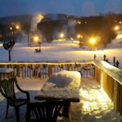
Feb 17...12 more inches in last 24 hours...over 20" in last 48 hours...forecast calls for 12 more inches by tommorrow morn,then more snow thursday and friday...total as of this morning is 212" for season with over 40" for current snow depth on the valley floor...folks are firing up all kind of back country lines everywhere and then only hitting the resorts when they have to go to work...I saw some pictures of some huge back country booters into waist high pow last night...everything goes and people are even tricklin' over to the east side of the allegheny for some first decents....
After a quick look at this
snowfall history table I found on the Whitegrass website, it looks like this February (at 84" currently) has already broken the record for the snowiest month ever in Canaan Valley - and we have 12 more days to go! Anyone think we'll break 100" in a month?
It looks like the previous record was 82.5" in January 2003...
95-96 is before my time in these parts. Was that winter as relentless as this one? No long thaws?
95/96 was relentless all winter starting with 55 inches for november..43 for Dec..60 for Jan..42 for Feb..40 for March..& 20 for April! I loved that Winter & have many fond memories of hanging out in Davis & skiing our rearends off in the Valley..we started to Fantasize about starting a back country tour guide service thinking (thru some good Smoke) that we were going to get winters like that all the time!
Another Tidbit...the greatest snow depth ever recorded was back in the coldest winter on record..76/77 when 83 inches was recorded on Feb 7th,1977...83 inches!!!
...nice footage...looks like some great turns...I don't know how you can stand those crowds...
Man... why oh why didn't I take Wednesday off! You gotta get it while you can in the mid-A!
Here's a link to some pictures from the past two Wednesdays at Tline. Looks like Thursday may be the day this week!
Tline the past two Wednesdays
Awesome video scottyb... thanks for sharing... it almost make me feel like I was there

SCWVA - great pics too!
105" and counting for the month of February in Canaan... I'd say they smashed the old monthly snowfall record!
I'd hate to jinx things but it almost seems like a sure thing that CV will break their record for the snowiest winter ever! Their current total is at 246" while the record stands at 258".
Anyone think they'll break the 300" mark?
Outside shot at 300". We'll need another big dump to give us a shot.
I think they will have another shot in 7-10 days but over 50" will be tough. Hopefully they can get 40-50 for the month then squeeze in an April surprise for 300+!!
Come on now, where's the optimism? In the past, march has had more snow than any other month. A couple of years ago, we closed down t-line in April with a weekend storm total of well over 20". I think it'll happen this year if it's ever going to happen.
If its ever going to happen this is definitely the year. Probably a once in 150-300 year event if we do. All we need is 52 inches! Really 2 good weeks (w/upslope) is all we need. I would say chance of breaking 30 is 50/50.
Easy!..we got till May to get it. 2 years ago it snowed the weekend before Memorial weekend..I got 4 inches at my Camp just South of the Valley at 3000'.
http://ocean.dmi.dk/arctic/meant80n.uk.phpThere is some cold up there Folks!..The arctic Ice extent which I thought had about maxed out has just spiked up due to the cold that has built up...For our Grand Finale??...Come on Late march/early April...DUMPAGE!!!..then we can go Fishin....
I think it's remarkable that there have only been 17 days without snowfall since December 17... in other words 80% of the days since then have had some snowfall!
All the local forecasters are saying winter is done east of the Allegheny front. This latest storm has marked a pattern change that has ended the run of storms tracking across the southern US and turning up the east coast. Expect the storms to start tracking through the plain states and turning northeast through the mid-west bringing warmer air to our area.
The odds of winter truly being over in the mountains of WV the first week in March is slim. The upslope snows that bring the mountains their best snow aren't solely driven by the southern storms. But it may be hard for 50" of snow to fall this March.
Since I hate making negative posts about snow, I should add to my last post that the pattern change will be good for the western ski slopes.
Could be a good spring out that way.
I dunno about the cries of the end is near as far as east coast storms go. The winter's pattern is still pretty entrenched and a slight moderation in temps for a week is not even close to bringing spring on. The Omega block in the central US coupled with the southern jet will provide ample cold air and moisture for the next month. I believe we can still expect the potential of snowstorms measured in feet from the mid-atlantic north until early April this year.
I love the optimism around here! I'm still hearing rumors of the potential for a good storm around the 16th...
I love the optimism around here! I'm still hearing rumors of the potential for a good storm around the 16th...
The Model Runs change up run to run...the last week has seen the worst consistency all winter. I think March confuses the Man Made Brains...
Wutch you talkin' 'bout Willis?