guess iconic ski scenes
August 16, 2011
84 posts
15 users
52k+ views
Just for fun, can you guess which ski area these photos were taken?
Guess 1:

whistler blackcomb "black tusk" in the background
Correct. That was easy. Here's another beautiful ski scene, can you guess the ski area at which the photo was taken
Guess 2:

Not sure but I'll guess Solitude.
Not sure but I'll guess Solitude.
Nope. Further east.
From same location, but more typical post card vantage point, guess #2(a):

I'm going with Telluride. #2= Revelation Bowl?
I've never been to Telluride, but the steep face in the background reminded me of other pix I've seen of the distinctive box canyon. (Too lazy to post!) Jim's second pic made it crystal clear.
Hey JimK,
Can you find any pix of cliff signs at Snowbird?

It's wild how the skier mind processes the look of these mountains without thinking about it.
For example, did anyone here see Inception and _not_ think 'Canadian Rockies near Banff'?
I've never been to Telluride, but the steep face in the background reminded me of other pix I've seen of the distinctive box canyon. (Too lazy to post!) Jim's second pic made it crystal clear.
Are there any trails on that face? I see what looks like an avalanche chute, the sort of thing that if you started down it might be too late to stop by the time you figured out what was ahead. The first time I drove west from Calgary I was amazed at how many ski areas were there - for about 15 seconds. Then I realized that those weren't ski trails, they were avalanche chutes.
Telluride (and Revelation Bowl) is correct. I've never been there either. Man, that place sure looks gorgeous.
JohnL induced self-hijack from scenery guess thread, supposedly this sign is on the hike up the Snowbird side of Mt. Baldy:

I've never been to Telluride, but the steep face in the background reminded me of other pix I've seen of the distinctive box canyon. (Too lazy to post!) Jim's second pic made it crystal clear.
Are there any trails on that face? I see what looks like an avalanche chute, the sort of thing that if you started down it might be too late to stop by the time you figured out what was ahead. The first time I drove west from Calgary I was amazed at how many ski areas were there - for about 15 seconds. Then I realized that those weren't ski trails, they were avalanche chutes.
Not sure if San Joaquin Couloir (renowned extreme, but skiable chute) is up there in either Telluride photo, but it's closeby. Here's a view of SJ Couloir from higher up in Revelation Bowl. Also, here's source of below photo in detailed thread from First Tracks (FUN STUFF ON 100 DEGREE DAY
):
http://www.firsttracksonline.com/boards/viewtopic.php?f=3&t=5854San Joaquin Couloir (upper left, distant rock face) from Telluride's Revelation Bowl, the narrow part thru the rocks has over 1000' vertical:

Thank you Jim, I just cooled off by 10 degrees!
Since it's still pushing 100 degrees outside I want to get this thread back on track...
can you identify the ski area where this photo was taken?
OOPS, I think djop saw my revealing goof, but let's see if any others can guess correctly after the fix?
guess 3:

Le Massif. It's a perfect match for their current home page picture.
Plus the slopes are going right down to the water edge - is there a place in Tahoe like that?
Plus the slopes are going right down to the water edge - is there a place in Tahoe like that?
Homewood and the California side of Heavenly are sort of like that. The top of Diamond Peak presents the illusion of doing that.
Correct answer is Le Massif in Quebec, Canada. I have been there and Heavenly in recent years and the comparison is not inappropriate.
Can you identify the ski area where the following photo was taken, guess 4?

??????????????
I swear I've skied there, but I'm not quite recognizing it...
First thought was peak chair at Whistler, but not quite.
Thought about Squaw Valley, but don't think so.
It looked a bit like KT-22, but I thought there were a few more cliff areas directly under the lift near the top. Guess not.
Guess 5: Top of Blackcomb Glacier?
The groomed road out certainly looks like Blackcomb backside.
I went across the pond for above shot, so Blackcomb is not correct.
Here's a big hint:
One of the great intermediate skiing cruises in Europe begins at the spot where this photo was taken (Vallugagrat, elev 8,692') and is filled with hundreds of turns as you work your way down for at least an hour to the valley floor.
Experts can take the final section of the cable car to the top and after a difficult climb-accompanied by a guide only-they're committed to a very challenging off-piste route that drops approximately 5000 vertical feet.
guess 5 buddy picture is from St. Anton, Austria.
Back in the USA, can you guess the ski area where this photo was taken?
guess 6:

Timberline, WV.
Very good Snowsmith. I've never been to Schweitzer Mtn, ID. It looks beautiful next to Lake Pend Oreille and Sandpoint.
This would be an iconic ski scene if not for turkey in the right foreground, guess 7:

Wow. Someone else in this world has the old Scott carbon poles. I love those.
someplace that is the hottest non-spammed topic over on SnowJournal. I'd say you are between Cannon and Mittersil.
I'd say you are between Cannon and Mittersil.
That gotta be it! I forgot that Cannon has a gondi and that looks the The Presidentials in the background. Mt. Washington? I know it's visible from Wildcat, not sure about Cannon.
someplace that is the hottest non-spammed topic over on SnowJournal. I'd say you are between Cannon and Mittersil.
GGNagy is correct, not only about Cannon, but location where shot was taken on the mountain.
Next photo is a reward for the faithful followers of this guess thread

Can you identify the ski area in guess 8?

What ski area? I see bikini's!!
Are they sitting in A Basin of water?
What ski area? I see bikini's!!
that's the waxed ski area.
*goes home*
*puts smaller baskets on poles*
I'd say you are between Cannon and Mittersil.
That gotta be it! I forgot that Cannon has a gondi and that looks the The Presidentials in the background. Mt. Washington? I know it's visible from Wildcat, not sure about Cannon.
I stood at that very spot about 2 months ago and should have recognized it. Perhaps it was the lack of snow.

I was there for the annual Mt. Washington pilgrimage over Memorial Day but the snow was almost gone so on day 2 I decided to go to Cannon, ride the tram and scout out the Tucker Brook trail. It is over the next rise that Jim K is facing, about a 200 - 300 vertical foot climb. It departs on the left from the broad (~30 ft wide) cut that Jim is facing. According to David Goodman's book, it is one of the true gems of the CCC trails, descending 2800 ft. to a dirt road lot thus requiring that one spot a car. I want to do it next winter. I'll post a heads up to try to find a partner. Otherwise I might go it alone, walk out to the main rd., and hitch a ride back to the tram base. I've done crazier things alone. Tucker Brook trail descends the 'wrong' side of the mountain thus ending a couple miles from the base of the lifts. It is actually the right (west) side where snow piles deep. The trail system was cut on the north side of Cannon and is prone to wind scouring. New England old timers lament this. I am not one of them, having never skied Cannon. When I was growing up in Boston it was too hard to get there; now it is easy on I-93. I skied Wildcat in those days, many times. BTW the higher peaks in the background of Jim K's pic are in the Franconia Range. The camera view is to the southwest. The Presidentials are to the northeast and if I recall correctly are not visible from that spot, being hidden by other high peaks on the east side of Franconia Notch.
http://www.telemarktips.com/GoodmanFeature.html
that's the waxed ski area.
What temperature range?
(Too hot for either one of us to handle.)
#8: Alta. Peruvian or close to it?
stood at that very spot about 2 months ago and should have recognized it. Perhaps it was the lack of snow. smirk I was there for the annual Mt. Washington pilgrimage over Memorial Day but the snow was almost gone so on day 2 I decided to go to Cannon, ride the tram and scout out the Tucker Brook trail. It is over the next rise that Jim K is facing, about a 200 - 300 vertical foot climb. It departs on the left from the broad (~30 ft wide) cut that Jim is facing. According to David Goodman's book, it is one of the true gems of the CCC trails, descending 2800 ft. to a dirt road lot thus requiring that one spot a car. I want to do it next winter. I'll post a heads up to try to find a partner. Otherwise I might go it alone, walk out to the main rd., and hitch a ride back to the tram base. I've done crazier things alone. Tucker Brook trail descends the 'wrong' side of the mountain thus ending a couple miles from the base of the lifts. It is actually the right (west) side where snow piles deep. The trail system was cut on the north side of Cannon and is prone to wind scouring. New England old timers lament this. I am not one of them, having never skied Cannon. When I was growing up in Boston it was too hard to get there; now it is easy on I-93. I skied Wildcat in those days, many times. BTW the higher peaks in the background of Jim K's pic are in the Franconia Range. The camera view is to the southwest. The Presidentials are to the northeast and if I recall correctly are not visible from that spot, being hidden by other high peaks on the east side of Franconia Notch.
I didn't think Mt. Washington was visible from Cannon.
I'll have to dig out an old ski mag; I think it mentioned the Tucker Brook trail on the backside.
#8: Alta. Peruvian or close to it?
Gotta agree. I've stayed at the Peruvian; every skier owes it to themself to do it once. Not just for the hot tub but for the whole experience.
quote]Gotta agree. I've stayed at the Peruvian; every skier owes it to themself to do it once. Not just for the hot tub but for the whole experience. [/quote]
We'll see. You and I were both wrong on the Blackcomb glacier guess.

You guys are correct about guess 8, it is Alta, UT. Not sure about exact location of hot tub, but Peruvian Lodge sounds likely, waxing likely as well.
Regarding Cannon and Tuckerbrook trail, believe that off-piste route is beyond to my right shoulder as facing in Cannon photo and goes down near Mittersill base, but not part of Mittersill trail layout, correct?
Can you identify guess 9? The terrain (double black diamond
) of two ski areas is visible in this photo:

Can you identify guess 9? The terrain (double black diamond smirk ) of two ski areas is visible in this photo:
BS. MB. With YC nearby.
That is the correct answer, Big Sky (Lone Peak above) and Moonlight Basin (Headwaters chutes to right). Piece of cake for JohnL to identify and ski
Going across the pond again...to a place known for bada$$ terrain with vertical drops on some routes approaching 7000 feet! Everything white in this photo is skied, albeit primarily by superhumans. The flat, white swath to the right beneath gondolas is a conventional steep mogul slope.
Can you identify ski area in guess 10?

La Grave- looking at the Grand Pic and the Glacier de la Meije?
Regarding Cannon and Tuckerbrook trail, believe that off-piste route is beyond to my right shoulder as facing in Cannon photo and goes down near Mittersill base, but not part of Mittersill trail layout, correct?
It is beyond your left shoulder and goes away from the Mittersill base. I believe they have just built or are planning to build a Mittersill lift to reopen some of M's historic terrain, but Tucker Brook will still be backcountry.
I too have skied the Big Sky and Moonlight Basin steeps, some of it that is. To ski all of the terrain in both those areas is beyond me.
djop, La Grave, France is correct! It's about 50 miles east of Grenoble and this is the area where the great extreme skier Doug Coombs fell to his death a few years ago. Here's a link to an informative report on the skiing at La Grave and source of above photo:
http://www.mensadventuretravel.com/?p=799A flurry of three final photos, not sure if all qualify as iconic scenes, but there is some noteworthy big air going on
Can you identify photos 11, 12 and 13, each from a different ski area/country?
guess 11:

guess 12:

guess 13, if anyone gets the location of this beautiful shot I'll be impressed:

idk, but #12 just scares the bejezzus out of me - where the heck is he going to land ?
idk, but #12 just scares the bejezzus out of me - where the heck is he going to land ?
At the bottom of Kirkwood.
I believe thats jimmy at the top getting ready to drop in.
No. 11 looks like the 7th Heaven area in Blackcomb...
At first I thought Lou's guess for #11 was correct, but now I don't think so. I don't recall there being that many buildings at the bottom and the lift starting at a the bottom of a drainage (IIRC it's higher up the mountain.)
If we need three different countries, US, Canada and Europe are the likely choices.
#12: Kirkwood or Targhee
#13: Looks a lot like New England to me. Backcountry near Stowe? But if the U.S. is already taken by #12, somewhere in Eastern Europe. Or mebbe inland British Columbia.
#11: Europe? Or Lake Lousie/Banff in the Canadian Rockies.
Clearly I'm guessing here and trying to mix and match the guesses.
You've saved the most challenging for last.
idk, but #12 just scares the bejezzus out of me - where the heck is he going to land ?
At the bottom of Kirkwood.
I believe thats jimmy at the top getting ready to drop in.
Yah, it's required as part of the T-Line instructor training. He'll be screaming "Bobyyyyyyyyyyyyyyyyyyyyyy, you ..." on the way down.
SCWVA is correct that 12 is Kirkwood, California. Agree, it's an amazing image, believe the jumper is Ron Shevock:
PMGear 11. Hint, Canada, but not Whistler Blackcomb.
13. Hint, I first saw this image when posted on epicski two years ago by a Euro. JohnL is getting warm.
11. Red Mountain
13. Somewhere in the Caucasus mountains in Russia. Near Sochi, site of the 2014 winter olympics.
Final answer, er guess.
You're thinking of Krasnaya Polyana
Heh I'm just lookin to see if the guinea pig survived.
idk, but #12 just scares the bejezzus out of me - where the heck is he going to land ?
At the bottom of Kirkwood.
I believe thats jimmy at the top getting ready to drop in.
Yah, it's required as part of the T-Line instructor training. He'll be screaming "Bobyyyyyyyyyyyyyyyyyyyyyy, you ..." on the way down.
Just picked up this thread...
Is that Tyrone Shoelaces (screen name on epic forums) in photo 12? Looks like him, and the kind of cliff he would jump.
As I scrolled through the thread, I nailed Telluride on the first pic (very few places with that type of terrain, my only other guess would have been Jackson Hole) and Squaw ("fingers" were a dead give away...the ultimate glory cliff jump on a powder morning).
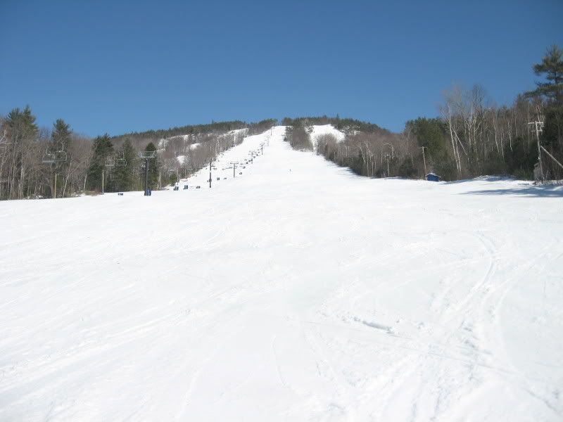
Here's an easy one.

I was going to say top of Loveland
I'd vote for Loveland also, thanks for posting a picture Pagamony. Got more?
(Believe Leo is correct about Tyrone Shoelaces.)
loveland is correct, but where am i standing and/or whats in the picture?
Jim, here is the next one... its a bit of trick question.

I guess the first Loveland photo was taken over by Zip Basin?
The second shot looks like Loveland too, but the lack of lifts on the far hillside is confusing me. Could it be from Keystone's North Peak?
Is this Keystone on the back side?
loveland location: guess another few times
Other location: right state, wrong place and time. try again and think historically epic.
loveland location: guess another few times
Other location: right state, wrong place and time. try again and think historically epic.
Is Loveland photo from top of chair 4?

Is second pagamony photo from Cooper where the 10th Mtn Div troops trained for WWII?
(#15) Loveland - patrol bowl looking back across chair 9 and the ridge, so in the region of chair 4 certainly.
(#16) Ski Cooper is right! Now what is that legendary visible landmark where so much of the training took place?
Yes, the far mountain is Chicago Ridge, where the extreme mountaineering training happened including several multi-week expeditions in subzero temperatures. Camp Hale would be far to the left across the ski area, parking lot and road, iirc. Behind me would be Tennessee Pass, and then further back Leadville.
(17) History strikes again
It's not so easy being on the other side of these guess where threads

The only reason I got Cooper was because I remembered that you visited there a few years ago. I've never been there.
This looks somewhere in the East. You say historic? But apparently still in operation. Didn't you go to Maine? That looks like a triple chair on the left. I'll guess Shawnee Peak, ME although this doesn't look big enough? Not that I've ever been there either.
ok Jim, you can post the next one.
for this one, think locomotion....
cranmore is correct, but was not referencing the skmobile. i'll give you one more guess on locomotion.
meanwhile, cranmore was a neat place in april, still 100% coverage even thick sunbaked crust in the trees. Sort of what tline could be with just a tad more vert, terrain, and money.
Locomotion=scenic railroad rides around North Conway, NH?
I spent the past weekend biking near the Maryland Scenic RR in Cumberland/Frostburg.
You're almost there. And now for the rest of the story. A ski train ran from Boston to North Conway, delivering great numbers of new enthusiasts in the 40s and 50s. They were taught by Hans Schneider's team of instructors, himself a famous immigrant fleeing Nazi occupation of Austria.
Isn't it your turn now?
"Locomotion" had me actually thinking of Mt Washington Cog Railway slope or Attitash. The former makes sense, but can you guess why the latter?
The North Conway Scenic railroad?
The mountain coaster?
Cranmore was the first mountain I skied in 1954 on a youth group trip. I was 13 and all my skiing until that time was hiking up and skiing down golf course hills in my suburban Boston home town. My skis were solid wood, no laminations and no steel edges. They cost well under $10 from Sears and had bear trap bindings.
My Aunt Mary rode the ski train from Boston to North Conway in the 1930s. She did ski a bit but claimed that the partying, tobogganing, sleigh rides, and snowshoe baseball were more fun. Wonderful pictures of this era can be found in "Mount Washington in Winter" by Winston Pote. It is now out of print but I will bring my copy to our next gathering. Mary passed a few years ago at age 102.
My son and I skied Chicago Ridge about 20 yrs. ago. I believe the snowcat operation is still running there. On our final run they took us to a 1700 vertical foot face that they said had not been skied for 2 years. We hiked the final pitch because the cat driver was afraid of rolling the cat if he attempted the top. It was a bit intimidating and nobody except my son answered when the guide asked who wanted to go first. So he did and I followed figure eighting his tracks. I counted 80 turns down to the tree line.