Sean Dougherty writes about a lost Pennsylvania ski area named Pine Forge:
Woody Bousquet provides the following scans of a brochure from Pine Forge.
“The brochure is likely an early one in the history of Pine Grove Ski Area,” Woody writes. “It shows rope tows only, but comments [from other readers] mention that the area had a J-bar (or poma) lift. That surface lift was probably installed after the publication of this brochure.”
Woody also provided the following image of lift ticket from Pine Forge.
Woody provides a Google maps satellite image of the area surrounding Gracie’s 21st Center Cafe, a restaurant now located in the building that reportedly used to be the base lodge for the ski area. Woody has marked with red lines his inferred location of the 2 rope tows shown in the brochure’s center spread.
I Learned to ski at pine forge in 1964. Remember it had a 268 foot vertical drop, one main very steep mogully slope and 2 rope toes. I think the lift ticket was $2 . The rope tow ripped up gloves real quick and they sold a device called a “nutcracker “ at the base lodge that you used to clamp onto the rope tow (to save your gloves). I still have the “nutcracker” device. The place was owned by the “Brown” family that had the cement block company in Stowe, Pa.. The area bragged that if you could ski the steep moguls there that you could ski anywhere. It was steep but short. Lots of good memories !
Just saw this thread now - my uncle used to own Pine Forge. My very first day of skiing (free!) happened there in about 1968 and I went on to become a ski instructor with 1200+ days so far. The comments above about the rope tow and ice are very correct. It was a cool place at the time but I doubt they ever turned a profit. Used to rent 50 cc mini bikes in the summer too.
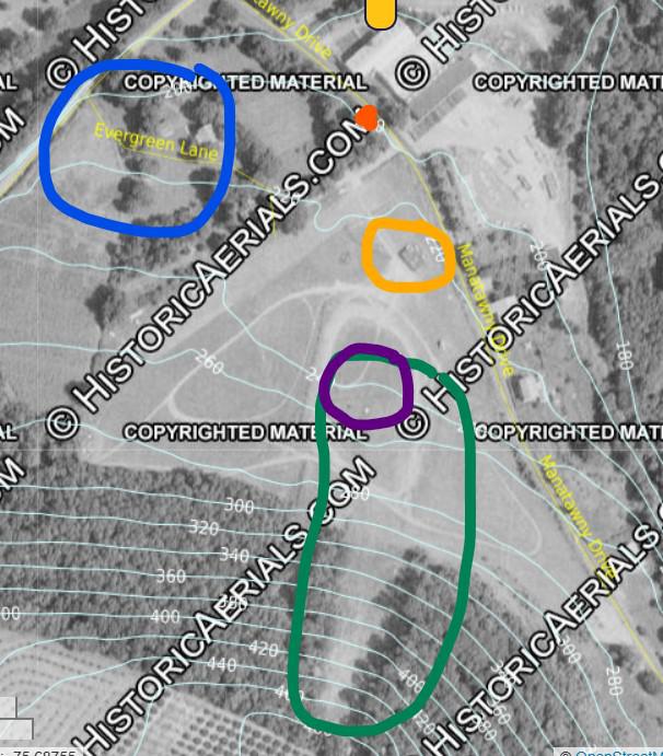
Doing a bit of research, I think there are some discrepancies in what and where Pine Forge was. The two claims I'd like to provide info on are on its exact location, and where the base lodge was. Let me provide a key for this 1971 aerial photo first:
Blue - Previously posited location of the area
Red dot - Where Gracie's is
Purple - likely location of the two lift shacks - appear to be in the same location as in the image for the ski school and advertising 268' of drop
Orange - Where the base lodge likely actually was
Green - Where the ski area was actually located
As you can see by the topo map, the posited location of Pine Forge can't be right - only about 60' of drop. The green area circled matches the ski school advertisement previously mentioned in shape and character, as well as more closely matching the 268' (about 240' of drop).
Gracie's also probably wasn't the ski lodge. Not only does there appear to be no building in its location in the 1971 aerial, but Gracie's is also on the road *before* it bends from SE/NW to mostly S/N. The likely lodge (orange) is a bit after that bend on the S/N section of the road.
The base of the area (about the 240' topo line) is currently the very edge of the steel plant's property line. From above, it appears the area was last kind of visible in a 1992 aerial. By 1999, you would be very gratuitous to claim to see its outlines. They are all but gone from above today.
Hope this is useful!


Join the conversation by logging in.
Don't have an account? Create one here.