How's T-line holding up?
March 7, 2011
33 posts
12 users
13k+ views
I'm looking at heading out next Thursday, is the base holding pretty well? Looks like some nice spring skiing could be in order.
its 24 degrees & snowing right now...
If your idea of spring skiing involves rain, next weekend should be spectacular.
On the other hand, right now it definitely still feels like winter up here.
You could be right Norsk but I wouldn't write off Canaan Valley yet..Could Get lucky fri ,Sat is iffy..Sun could be Snowy.. There is definitely a rain before snow(hopefully) period. Should have better Model agreement by Mon.
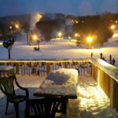
OK, Tline is holding up quite well it seems. Big bomber base on all the main slopes. This morning was cold, rock hard and very fast. By the afternoon, temps warmed up enough to soften the snow, and on the western exposure it began to feel like Spring. I think (fingers and toes crossed) they can survive the pre-snow storms this week/end.
I second that. Saturday morning was a bit icy but things softened up very nicely by the afternoon. Great base on The Drop, OTW, WL, Thunderstruck etc - these should hold up nicely for a while unless something really drastic happens with the weather.
My favorite run of the day was Thunderdraft, under the lift - started off as icy moguls with enough windblown powder in the troughs to still be nicely skiable, softening to classic spring moguls in the afternoon. Nothing like some soft spring moguls to fool me into thinking that I can actually ski bumps. There were a few places on this run with mud and grass poking through, so I am afraid that we might lose this one after the next rain event.
FYI for those keeping score at home OTW was groomed and the drop was mostly groomed (there was a nice strip of moguls to skier's right).
It was busier than I expected for the weekend after President's day, epsecially given the warm temps we've had recently, so hopefully this is a sign that interest will remain high into March.
Sounds like a great spring day at Timberline. I love the JohnL quote in your signature!! I'm sure he's pulled that one out on plenty of DCSkiers!!
Blue bird skies, warm winds, and sweet potatoes everywhere. (that's a mix of sugar and mashed potatoes) Pretty heavy stuff. I really felt it for the USSA racers on lightening. What needs to happen is about 6" of fresh to mix in with the crud on top then a set-up. I think we'll get the set-up minus the fresh. I got a PSIA event there on tues-wed and really don't want to do it in Sunday's conditions.
the natural snowpack above 3800 has lost an inch or so in the past week, so I am sure Tline is holding up just fine. Wish I could say the same thing about Talheim Village....
these should hold up nicely for a while unless something really drastic happens with the weather.
Drastic as in the 55 degree, foggy/hurricane speed winds, and torrential rain that's going on right now? Just like a blow dryer to slopes.
the natural snowpack above 3800 has lost an inch or so in the past week, so I am sure Tline is holding up just fine. Wish I could say the same thing about Talheim Village....
That's what I hear. Sounds like the whole place is going to have to be scrapped. Hopefully they had good insurance.
http://www.wboy.com/story.cfm?func=viewstory&storyid=95062
That sucks. Which building was it?
I was told it was the middle building. That's terrible news. I hope they had their HOA insurance paid up.
Drastic as in the 55 degree, foggy/hurricane speed winds, and torrential rain that's going on right now? Just like a blow dryer to slopes.
That would do it, so hopefully the torrential rain will not continue for an extended period of time...rest of the week looks like it should be pretty clear. I'd be interested in hearing some on the ground reports.
I was told it was the middle building. That's terrible news. I hope they had their HOA insurance paid up.
That is terrible news. Is it the HOA that is responsible for making sure that a good insurance policy is in place, or the individual condo owners?
Drastic as in the 55 degree, foggy/hurricane speed winds, and torrential rain that's going on right now? Just like a blow dryer to slopes.
That would do it, so hopefully the torrential rain will not continue for an extended period of time...rest of the week looks like it should be pretty clear. I'd be interested in hearing some on the ground reports.
I second on the ground after the rain reports.
Usually the HOA is responsible for insurance on the structure as a Common Expense, and individual owners are responsible for insurance on the personal property contents at their own expense.
Finally below freezing. Things are going to be an ice cube tomorrow.
The Temp Drop wasn't exactly what you would call "march coming in like a lion" & the early call F-casts of sustained cold & Snow is a bust so far

...Still some cold shots coming down like this one hopefully ....
http://www.met.sjsu.edu/weather/models/gfsone-00/850tmpcf252.gif..But i'm not too excited about any weather events YET..Hope that changes...
Went to the UNCW VS West Virginia Baseball Game Sun (WV Got Walloped...8 ZIP) & was burning up in the Stands till a sea breeze kicked in..Had My AC on today...I NEED ONE MORE COLD BLAST..KICK [censored] WEATHER EVENT to say goodbye to winter & I hope it don't come too late!..
You could be right Norsk but I wouldn't write off Canaan Valley yet..Could Get lucky fri ,Sat is iffy..Sun could be Snowy.. There is definitely a rain before snow(hopefully) period. Should have better Model agreement by Mon.
Friday: Partly sunny, with a high near 45. South wind between 9 and 11 mph.
Friday Night: A slight chance of rain showers before 3am, then a chance of rain and snow showers. Mostly cloudy, with a low around 32. Windy, with a south wind 13 to 16 mph increasing to between 26 and 29 mph. Chance of precipitation is 30%. New precipitation amounts of less than a tenth of an inch possible.
Saturday: A chance of rain and snow showers before 10am, then rain showers. Some thunder is also possible. High near 46. Windy, with a south wind between 25 and 29 mph. Chance of precipitation is 80%. New precipitation amounts between a tenth and quarter of an inch possible.
Saturday Night: Rain showers before 1am, then rain and snow showers between 1am and 3am, then snow showers after 3am. The rain and snow could be heavy at times. Some thunder is also possible. Low around 31. Breezy, with a south wind between 17 and 23 mph, with gusts as high as 34 mph. Chance of precipitation is 90%. New precipitation amounts between three quarters and one inch possible.
Sunday: Snow showers. High near 33. Chance of precipitation is 80%.
A little Washy..but not a complete wash out...Thank you...Thank you very much...
If you took what the NWS was saying about this weekend ..Last weekend..you would have said the same thing as norsk..Next Weekend will be a washout!!
The above F-cast I posted was actually a pinpoint F-cast for 4572'centered on Mount
porte Crayon because it was the only F-cast I could find all week that came close to what I said last Sat that might happen, but NWS dropped it right after I posted it & put back the rain all day sat & sun/ snow sun night F-cast...
Bottom line..Don't let a NWS f-cast ruin a ski outing for you..ck other sites like what Snowshoes website said yest & what your "Humble' fake weather dude..Me.. told you over a week ago (You need to sign up to Good ole fishky's AMAPRO weather svc)..below was from SS's snow report yest.
We know the topic of the day is going to be weather. Whether you're already here now or you're considering heading to the mountain in the near future, we know you're looking at that forecast and grimacing. But the news might not be as bad as it appears at first glance. For consistency purposes we report the National Weather Service forecast on these reports daily. But everyday at about 11am we receive a report from a service that we've contracted with on the mountain. They receive weather data from the snowmaking equipment on the mountain and provide us with a forecast that has been by far the most accurate all season. We can't use that on the morning report because it's not ready prior to our report posting at 7am, but we want to let you in on what Precision weather is telling us about this weekend; Saturday will have increasing clouds throughout the day with rain starting LATE in the day (so you may get in a WHOLE day of skiing without a drop of rain.) Periods of rain overnight Saturday with rain TURNING TO SNOW on Sunday, before it tapers off. It seems that Mother Nature might just know how much we have going on on the mountain this weekend and she's going to hold off that rain and possibly drop as much as ONE TO TWO INCHES OF SNOWFALL tomorrow!
Oh..by the way, its snowing up at the shoe right now & Canaans next!!...& the rain held off much of the day yest..
But then they post this at 823 AM...(It was Snowing & 33 degrees at the top at 823am & they posted a 40 degree temp)..ck out Highcountrywebcams.com..ALL WHITE!..Go figure..
The weather will likely dominate the conversation again this morning...So, let's jump right in. The overnight temperatures stayed mild, which prevented us from making any snow last night. Additionally, we received periods of off-and-on rain most of the evening and into this morning. The forecast is calling for more rain today, but with temperatures dropping throughout morning that rain should turn to snow by early afternoon and into the evening
Hopefully those areas can squeak out a few inches by midnight.Wonder if the western territory was lost for the season seeing it isn't on the schedule for today.
Long live the WV Alpps...Dumpage showing on all Cams!
Old Timberline, Davis, West Virginia (PWS)
Updated: 4 min 20 sec ago
27.8 °F
Heavy Snow Freezing Fog
Windchill: 28 °F
Wuzzz upppp???..NWS just put out a Winter weather advisery LOL..Should have made it a Belated Winter storm warning!
Am I the only one Cking this scene out??...I would have been up at canaan this weekend but my place up there rented..The renters who took a big gamble on this weekend are going to be luvin the hot tub & Cheering life after a great Day of skiing in a March storm!
PS..Southern Alpps gettin it too!
Four inches of fresh snow so far and its still coming down! YEAH! 100% open with good coverage. Tomorrow and Tuesday will be ideal Spring skiing days
Been @ the Shoe since Wed. Awesome Bluebird Days and super conditions until Saturday afternoon. Only slightly less crowded despite the rain forecast. It has been snowing heavy since about noon and still coming down. 19.6 degrees now. Tomorrow, should be a Bluebird Day and high of 33. Got lucky, we have been from spring to 19.6 degrees and near blizzard conditions in less than 24 hours. Only in WV.....Cheers!! Headed out to hot tub.
Dave Lester is reporting 7 inches in Canaan Heights as of 7 PM.
The worm has turned Mr. Fish.
From the WG web site early eve update...(& Cheers right back at ya BlizzardMax!)
New Snow: 5" here and 8" up high so far
Snow so far this season: 182"
6 PM weather: 25 hard straight down snow
man who puts skis away this time of year pulls them back out soon, like now
Skiable days: 91
I'm guessing 10 or so up high..took a little while to get the snow level down to the valley floor..nice little march surprise!
The Worm will be poking up from the ground later this week before quickly going back in hibernation JohnL..
Drove home from t-line yesterday, or tried to. We left around 2:30 PM. Three out of four mountains we crossed had the summits closed due to heavy wet goop falling and causing carnage. Allegheny, Shenanadoah, and Blue Ridge on Rt 33 to the flat lands. 3 hour trip took 11. My gas mileage went to he11 as well. Met a lot of t-line skiers in the back-ups and we raved of the conditions we enjoyed which caused the late arrivals to our destinations. Not bad though... only the 3rd time in 25 years this has happened.
I know I will not be out there this month. So it it weird that just knowing all that snow is out there is making me happy? Long live the Valley!
Drove home from t-line yesterday, or tried to. We left around 2:30 PM. Three out of four mountains we crossed had the summits closed due to heavy wet goop falling and causing carnage. Allegheny, Shenanadoah, and Blue Ridge on Rt 33 to the flat lands. 3 hour trip took 11. My gas mileage went to he11 as well. Met a lot of t-line skiers in the back-ups and we raved of the conditions we enjoyed which caused the late arrivals to our destinations. Not bad though... only the 3rd time in 25 years this has happened.
11 hours to make a 3 hours drive? Come on now Kim, I thought you knew better than that. That's what sick days are for. Could have skied the pow all day, started the lifts up this morning, left at noon and been home by 3. I'm upset with your lack of effort!!
could've done that but both me and thre mrs. played hookie for three days prior to the weekend. We we're already pushing our luck.